Ruben de Rijcke, CC BY-SA 3.0 https://creativecommons.org/licenses/by-sa/3.0, via Wikimedia Commons
This report by Bromley Living Streets presents key data on air pollution and safety around Bromley schools, and presents ideas for how Bromley residents can take action to improve their neighbourhood between now and the May 2022 local elections.
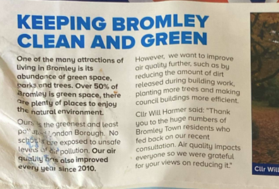
Bromley Council is under Conservative control, with Conservative councillors in 50 of the 60 seats in Full Council. This report takes as its starting point the recent claim made by Bromley Conservatives that “no schools are exposed to unsafe levels of air pollution” in the London Borough of Bromley (see below).
First, we make the case that the use of the word “unsafe” is factually incorrect in this context. We draw on the same modelled data used by Bromley Conservatives, as well as commitments made by Bromley Council in its Air Quality Action Plan. We also present air quality data we have collected ourselves in June and July 2021, using the Flow2 portable air monitor produced by Plume Labs.
Second, we present data collected through our School Travel Survey, indicating high demand for action to improve roads around Bromley’s schools. 5,500 Bromley parents responded to our School Travel Survey last autumn, and the overwhelming message was that parents would love their children to walk or cycle to school, but at present they do not feel local roads are safe enough.
Third, we make the case that it is entirely possible to imagine better streets for Bromley borough, particularly around schools. We present a visualisation showing what some of our roads could look like if they were redesigned to serve the needs of people travelling on foot or by bicycle as well as people travelling by car or bus. In a future report, we will present information about Bromley’s existing 6 school streets, and the amount of money Bromley Council might have available to spend on improvements to roads once Bromley starts enforcing traffic offences (Bromley is the last borough in London to do this).
Local government elections in May 2022 represent a key opportunity for Bromley residents to push for improvements to their neighbourhoods, as all borough councillor seats are up for election. With this in mind, our report also suggests some actions local residents can take now in order to ensure that better streets for Bromley are firmly on the agenda for the May 2022 elections.
Bromley Living Streets is a group of residents in the London Borough of Bromley, campaigning for safer, quieter streets suitable for all people and all modes of travel, particularly walking, cycling and public transport. We have been doing this since August 2018 as volunteers, because we believe it is the right thing to do for the people of Bromley and for the planet. Bromley Living Streets is a local group of Living Streets, the national charity for everyday walking. You can contact us here. We would love to hear from you, particularly in the coming months as we start to talk to political parties about what they intend to commit to if they are successful in the May 2022 elections.
What do you think?
Do you have ideas about the street where you live, a street you frequently travel on, or a street where children go to school?
You might want to consider presenting data and evidence to your councillors, and Bromley Living Streets is willing and able to provide support to you with this. You could monitor air pollution outside your local school or create visualisations of what ‘problem roads’ near you could look like, as we have done here. You could start a local community conversation about this, and Bromley Living Streets would be very happy to talk to you, your school or community group about what can be done locally – we have been doing this for the past 3 years. You can also ask their councillors what action they are taking and why they aren’t creating more school streets.
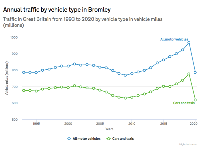
Let us know, and let your councillors know – otherwise they will approach the elections next May with the idea that all their constituents want things to stay as they are. This is a problem because in fact things will not stay as they are, they will get significantly worse: current trends indicate massive increase in vehicle miles in Bromley borough, the annual traffic by motor vehicles has increased from 800 million to a billion between 2009 and 2019. Unless we support people to get out of their cars and travel on foot or bicycle where possible, the future of Bromley’s roads is traffic jams, and congestion is bad news for anyone travelling by road.
How safe is the air Bromley children are breathing on their way to school?
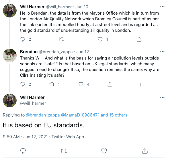
In early June 2021, as the dust settled on the London Mayoral elections, Bromley Conservatives launched their election campaign for May 2022 local elections with a leaflet that claimed that “no schools are exposed to unsafe levels of air pollution.” Over Twitter, Cllr Harmer has clarified that this claim was based on modelled data from the Mayor’s Office and EU standards.
There are a couple of problems with the claim made by Bromley Conservatives. First, it is factually incorrect – because there is no ‘safe’ level of most air pollutants. This is according to the World Health Organisation (WHO):
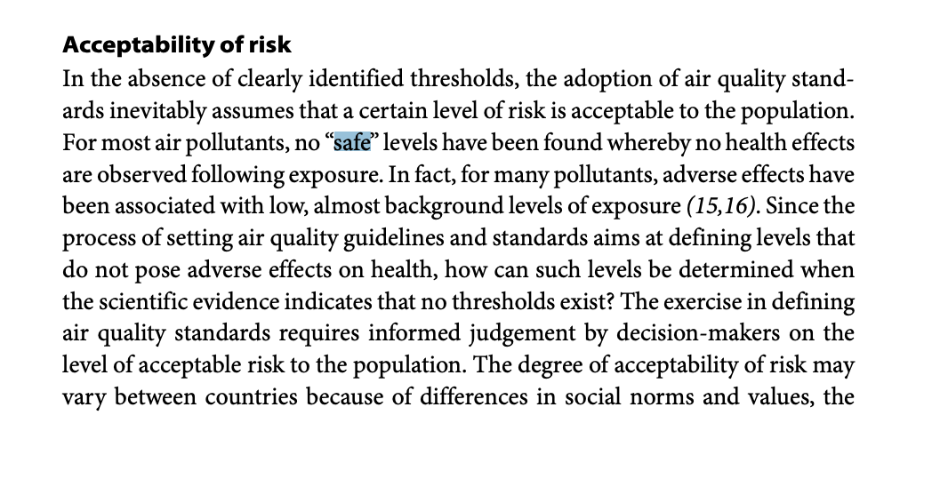
This quote comes from page 188 of this report. The obvious response to this point is contained within the twitter exchange and WHO quote, above: societies choose a level of risk that is acceptable to them, and enshrine this in law – i.e. what Bromley Conservatives meant to say is that no schools are exposed to illegal levels of air pollution. However…the Bromley Air Quality Action Plan explicitly makes this point about there being no safe level for many air pollutants and states the council commits to target compliance with WHO guidelines in future.
So how do Bromley schools measure up against WHO guidelines?
We have collected data that shows a different story, as every school we visited with an air quality monitor during June and July exceeded WHO guidelines, and even the modelled air quality data used by Bromley Conservatives shows air pollution outside many Bromley schools exceeds WHO guidelines (see the end of this report for more on this). We would love to discuss these findings further with Bromley councillors.
To test the modelled data used by Bromley Conservatives in their leaflet, we collected air quality data around several Bromley schools during the morning peak period. The air quality monitor we used, the portable Flow2 monitor produced by Plume Labs, is estimated to be within 10% of accuracy. The data gives good reason for concern about air pollution outside some Bromley schools. We provide one case study below, and will share data from other schools in the coming weeks.
Valley School
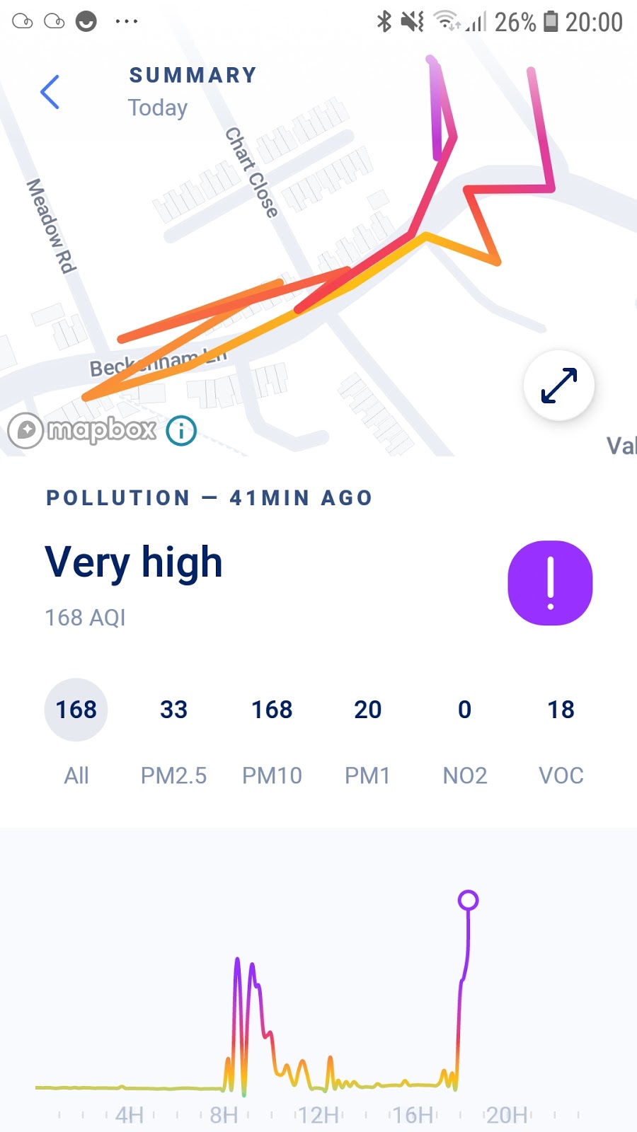
This image shows air quality on the school run for one of us, at Valley School in Shortlands village, in Bromley Town ward. The two purple peaks on the left of the chart are 8.30am and 9am. Both peaks are at the end of Farnaby road. In between, we walked to the school gate, did the school drop-off, then went to the shops in Shortlands village, then went home. The pollution level subsides in the school playground.
The purple colour of the peaks on the chart indicate air pollution is ‘Very high’ according to the Plume Air Quality Index used in the Flow2 monitor. You can read more about the Plume Index here, but the key point is that the categories in the Index (Low, Moderate, High, Very High, Excessive) are linked to the exposure limits outlined by the World Health Organisation, with each category representing the amount of time it is safe to spend in that level of pollution.
The meaning of ‘Very high’ is that effects will immediately be felt by individuals at risk, and everybody feels the effects of prolonged exposure.
Data on how Bromley children travel to schools, and how they would travel to schools if they felt roads were safe
“I wish it was safe for my children to cycle to school. I hate adding to the pollution.”
Parent response to the Bromley Living Streets 2020 School Travel Survey
Air pollution can be reduced significantly with changes to street design and transport infrastructure such as school streets. The cause of the air pollution outside Bromley schools is motor vehicles. Many of these are on the school run. Could we get parents and carers to consider alternatives to driving their children to school? We believe that in many cases the answer is yes. Our September 2020 School Travel Survey strongly supports this, with 5,500 responses with Bromley parents indicating, that they would encourage their children to walk, cycle or scoot to school if they felt it was safe to do so. It is not a question of parents being unwilling to take more sustainable modes, but a lack of adequate street infrastructures to allow children and parents to walk and cycle safely. How could we make this possible?
How the school run could look if we improved the public realm for all road users
Here is a visualisation showing what some of our roads could look like if they were redesigned to serve the needs of people travelling on foot or by bicycle as well as people travelling by car or bus.
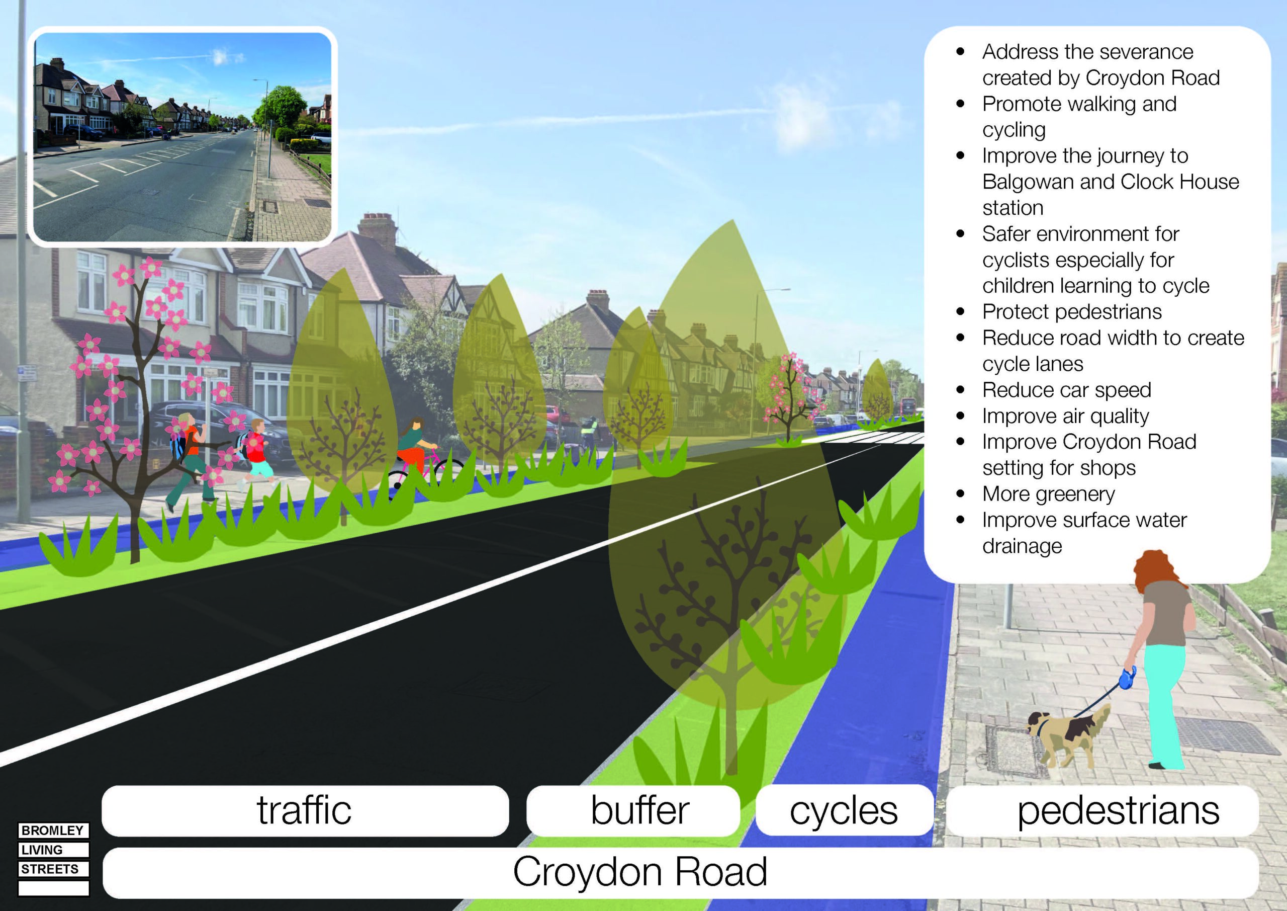
Some things to note:
This street is safer and more pleasant for people travelling on foot or by bicycle.
This street is also better for people travelling by car or bus because there will be fewer motorised vehicles and so less likelihood of traffic.
Not all roads are suitable for modifications of this kind. Some may be suitable for other kinds of modifications/measures aimed at traffic calming, such as school streets, or a wide range of options such as those detailed in this document: http://content.tfl.gov.uk/achieving-lower-speeds-toolkit.pdf
Redesigning our roads to serve the needs of all road users is not impossible, a pipe dream, or pie in the sky. ‘Modal shift’ – supporting people to use cars less and walk or cycle more – has been successfully achieved in many European cities and some UK areas (such as Waltham Forest).
Redesigning our roads to serve the needs of all road users is government policy. In February 2021, Transport Secretary Grant Shapps stated that half of all urban journeys must be on foot or by bicycle by 2030. You might also want to look at the Gear Change plan, published by the Department for Transport in July 2020.
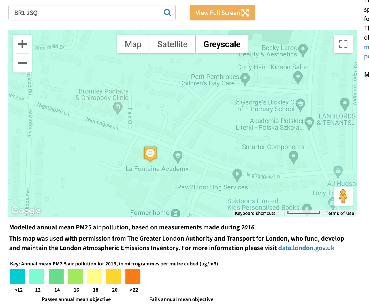
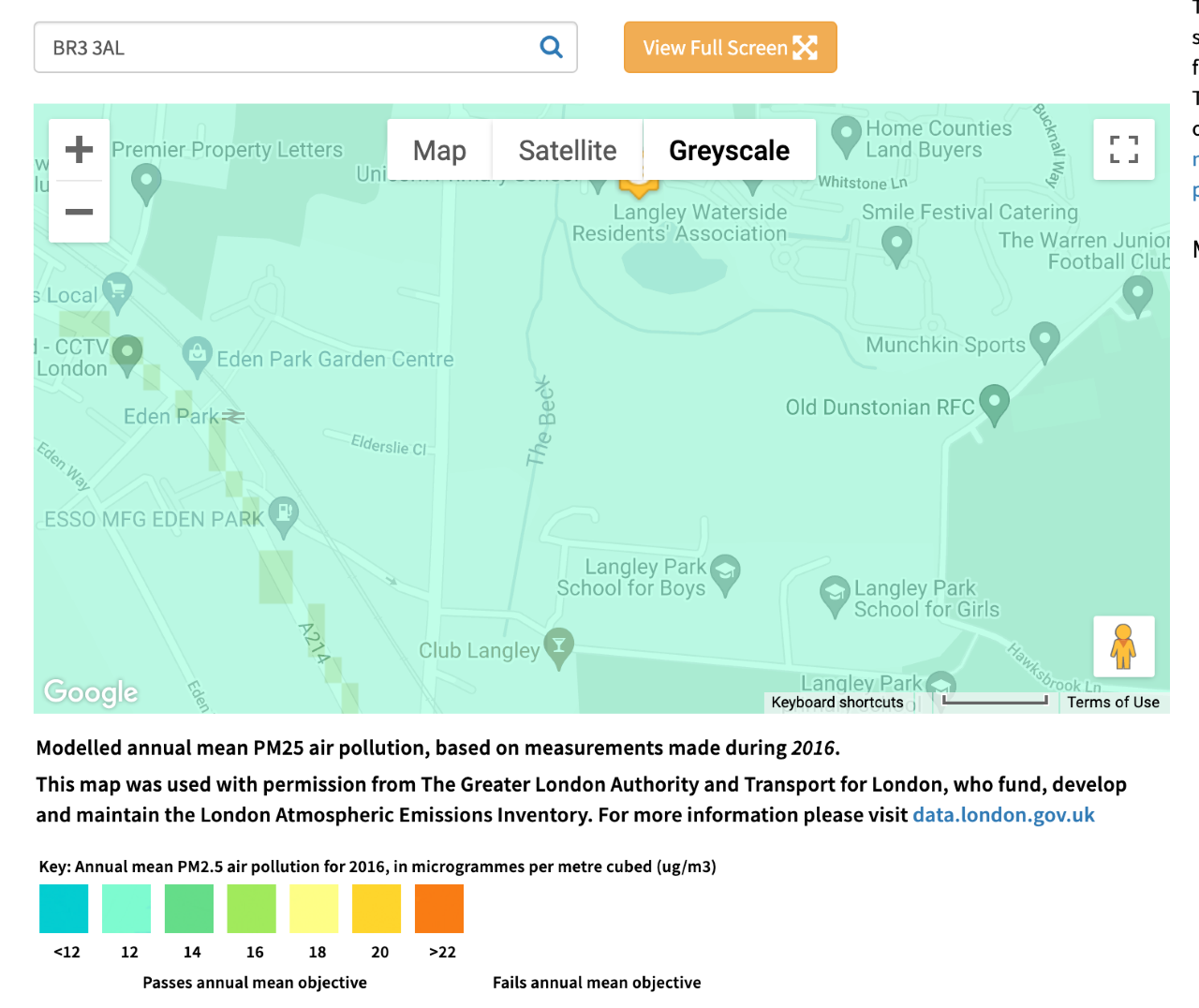
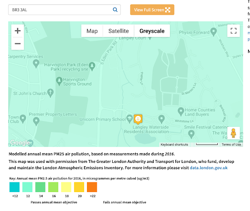
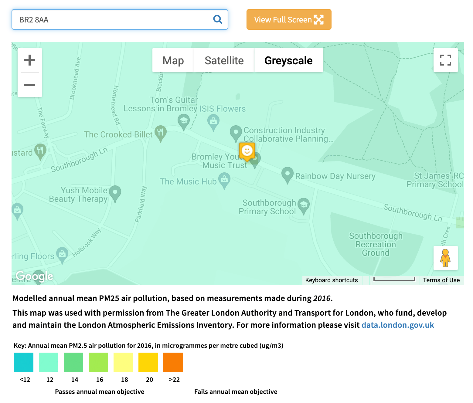
Modelled air pollution at Bromley schools
Below are images of modelled air pollution taken from the London Air website for selected Bromley schools, all of which show air pollution levels higher than World Health Organisation (WHO) guidelines. We hope parents at these schools will use these images to ask their councillors what they are doing about this issue.
In each of these images, air pollution levels are above the WHO limit for PM2.5 (10µg m-3) – probably somewhere between 12 and 14. At present, the EU limit for PM2.5 is 25 – but the EU plans to tighten air pollution limits next year, to better align them with upcoming World Health Organisation recommendations.
Here’s how you can produce your own images of data for your street or area: Go to the map on the London Air website and insert a postcode. There’s a drop down below the map to select different pollutants. Then take a screenshot. That’s all you need to do.