Public consultation: Anerley Hill/Anerley Road proposed bus priority and pedestrian safety improvements

Bromley Council is currently consulting on a scheme to improve pedestrian safety and the reliability and punctuality of bus services on Anerley Hill/Anerley Road, between Crystal Palace Parade and Seymour Villas.

Proposed changes at intersection of Anerley Hill and Terrace Straight (entrance to Crystal Palace Park)

The proposed scheme includes:

  • Several lengths of bus lane to give priority to buses (within the current road space)
  • A new zebra crossing immediately to the north of the Thicket Road and Versailles Road junction
  • Continuous pavement crossings at side road junctions (also known as Copenhagen crossings)
  • The re-designs of the Terrace Straight and Anerley Park junctions to make it easier and safer for pedestrians to cross.
  • A new pedestrian crossing point immediately to the north of the Terrace Straight junction
  • Additional car parking near the junction of Hamlet Road to help support local businesses.

View the detailed drawings here: Anerley Hill/Anerley Road proposals

How to contribute:

  1. Complete the online questionnaire
  2. Attend the public exhibition at Anerley Town Hall, Tuesday 23rd January between 14:30-19:30
  3. Contact us at bromleygroup@livingstreets.org.uk to share any comments or issues that you would like to raise to our attention

The consultation closes on Thursday 1st February.

New Beckenham Station underpass – concerns over new barriers

In November 2023 Bromley Council installed new barriers at the underpass next to New Beckenham Station, pictured below.

Photo showing chicane barriers at the entrance to the underpass by New Beckenham Station

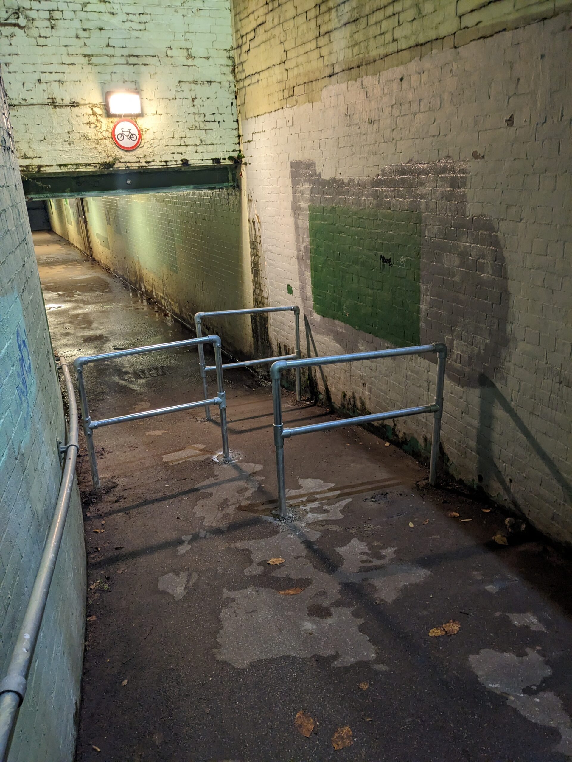
Shortly after these were installed, we contacted ward councillors and council officials to raise concerns about the design of these barriers. Specifically the gap of ~1.15m between each barrier creates a very tight path for anyone travelling on a mobility scooter or wheelchair, using a cargo bike or handcycle (when dismounted), or with a double buggy.

As far as we know, council officials are considering whether the barriers could be adjusted to improve accessibility. We will continue to pursue this issue as the underpass is a key link for walking, cycling and wheeling around Beckenham, and maintaining access for users is essential. Please contact us at bromleygroup@livingstreets.org.uk if you would like to get involved, or have concerns you would like to raise.

16 Bromley schools are doing the Sustrans Big Walk and Wheel 2023! Is yours?

Alexis O’Toole from Who The Hell Knows Anymore, USA, CC BY-SA 2.0 https://creativecommons.org/licenses/by-sa/2.0, via Wikimedia Commons

Do you have one or more children at school? If the answer is yes, ask your child/ren’s teachers to register their school now for Sustrans Big Walk and Wheel, the UK’s biggest inter-school walking, wheeling, scooting and cycling to school competition.

Sustrans Big Walk and Wheel inspires pupils to make active journeys to school, to improve air quality in their neighbourhood and discover how these changes benefit their world. What’s not to like?

So far, 16 Bromley schools have signed up to participate in the Sustrans Big Walk and Wheel 2023. There are more than 100 schools in the Borough. Help us increase the number of schools participating today!

Sustrans Big Walk and Wheel 2023 runs from 20 til 31 March.

15-Minute Cities Webinar – Recap

In case you missed last night’s webinar on 15-Minute Cities, this blog post summarises the presentations by Alice Roberts from CPRE London and Jeremy Leach from London Living Streets.

Alice Roberts: Planning for sustainable transport
At CPRE London we talk a lot about development because there’s a strong relationship between development and land use. Today, I want to talk about density as this is a common issue around London. We have spent a long time, in Enfield for example, looking at issues around densification and finding space to build. I’m talking about the interplay between density, green spaces – including the green belt – and transport.

At the heart of urban planning you’ve got a choice. You can have a sprawling city that tends to be low density, which is high-carbon by definition because more things have to move around further, and they tend to move around by car. The sprawling city is characterised by less active lifestyles because people are using cars. We call this a ‘climate unsafe’ environment because that is high-carbon. A compact city, on the other hand, will have something constraining development around it, like a green belt, so that it does not sprawl into the countryside. It’s more likely to be high-density development, lower-carbon, it would rely more on public transport, walking and cycling. Public transport is more viable as density increases, and more walking and cycling in a higher-density environment supports health. We call this a ‘climate safe’ environment because it is lower carbon. Slide 3 shows London’s Green Belt – the green areas are very important, and if you can see Bromley in the south east, it has a a lot of green belt area.

Moving to the density issue, the photos on Slide 4 are from Dartford. They show interesting densities – on the left you’ve got something with 25 dwellings per hectare and on the right, 69 dwellings per hectare. Neither have blocks of flats or tower blocks, but there’s a huge difference in density. The most important thing to remember is that anything below ~60 dwellings per hectare means that you cannot support public transport well. Ideally, you’d be up near to 100, but 69 dwellings per hectare is at least able to support a bus service to be financially viable.

Slide 4 (Click image to see a higher-resolution version)

The density debate is strong, particularly in outer London boroughs. Density is not a new thing. These two pictures on Slide 5, one old and one new, are high density but not necessarily what comes to mind when people struggle with the idea of density. They’re often thinking about high rise blocks, and frankly, in many cases that is what’s happening. We don’t support that, mostly because it’s not popular in many areas, but also it’s not a great way for families to live, in a very large high rise block.

Slide 5

Slide 6 shows a site in Enfield that will be developed, clearly showing the links between land use and transport. There is a car-dependent retail centre on the A10 in Enfield with a vast area of surface car-parking that encourages car trips and is a poor use of space. We’re trying to move to a situation where people need to make fewer car trips, and one of the ways to do that is by increasing density. This development will likely convert a large car park to a very high-density development – much higher than we or local campaigners support in that area. We think they could have got a lot of housing build without tower blocks, but that’s a separate story. Slide 7 shows an example of what we might support. The Assembly in Hounslow is 4 stories, and it is a car-free development. This means that people who live here cannot get a car parking permit, except for disabled residents, so you’re not adding cars to the local streets as a result of the development.

Slides 8-9 show how density has benefits. Land is used more efficiently – the land cost is lower per dwelling, partly because space is not needed for car parking, but also because you may have 3-4 dwellings on different stories. A wider range of shops and services can be supported, and critically, people benefit from faster, more reliable and frequent public transport systems because they become more effective in energy and cost. The cost of personal transport also diminishes as density increases, and better transport means better access to jobs and leisure, partly because higher densities can support those services. The cost of providing services also declines, as does isolation and social exclusion for people without a car. Density enables greater vitality and diversity, more services and facilities, a wider choice of restaurants theatres and cinemas may be available. Above all, in higher-density urban areas, this diversity is within easy reach of where most people live, so ease of access is a key factor which has critical implications for a sustainable quality of urban life.

Let’s think about what a 15 minute walk looks like in an area like this – Slide 10 shows a 15 minute walk from Bromley centre, in purple, and the pink area is a 15 minute cycle. If you’re talking about a 15 minute city, it needs to be 15 minutes walking really, either intensifying smaller centres to improve their viability or focusing on larger town centres. You can do it one way or another, but the housing has to go somewhere. While we don’t support the huge targets that councils are being given, we need to get on board with findings space to build. The choices are about, do we densify neighbourhood centres, do we densify town centres within Bromley, or what do we do?

Slide 10 (Click image to see a higher-resolution version)

People often don’t realise that a quarter of houses in Bromley don’t have access to a car. That is one of the lower figures, but it is still a lot of households. Those residents will be served better if they can move easily by public transport, walking and cycling to access local shops and amenities. Slides 11-12 come from the Healthy Streets Scorecard project. Slide 11 shows that the sustainable mode share, the proportion of trips by public transport, walking or cycling, is low in Bromley – just below 50%. That is a problem, so, as London densifies we cannot put more cars in. We need to think about how we can shift people from car journeys, not necessarily from owning cars but from using them so frequently, to public transport, walking and cycling. Thinking about how density interplays with that is important. Slide 12 shows that interestingly, the number of adults walking regularly is high in Bromley. It compares for instance with Southwark, at 40%. While it needs to be higher for people to be healthy, it was interesting that Bromley residents are already walking a fair amount, even though there are a large number of car journeys and cars in the borough.

To conclude – this is a picture of what we might like to be working towards, a vibrant neighbourhood centre that is attractive, sustainable and viable.

Slide 13

Jeremy Leach, London Living Streets: 15-Minute Cities for Bromley – Making Bromley a Great Place for Active Travel
I’ve looked at Bromley as a borough, but particularly at Beckenham, Bromley and Orpington in relation to active travel – walking and cycling – and how that complements the idea of compact living. Living Streets was formed as the Pedestrians Association in 1929, London Living Streets is an umbrella for the borough groups across London, formed in 2016. London needs to became a liveable city, a walking city, and inclusive city and a healthy city and a safer city. We’re advocates for walking, but also strong advocates for great places.

Slide 3 shows a nice example Waltham Forest in outer London, Francis Road in Leyton. In 2018 they won awards based on the transformation of a relatively unsuccessful local shopping parade, by closing it to motor traffic from 10am-8pm and making significant public realm improvements. These changes were taken on board by the local businesses, traffic volumes more than halved and the local economy boomed. Slide 4 shows another example of pedestrianisation scheme around Herne Hill station, where 2/5 of people agreed that people were spending more money in the area and 2/3 of pedestrians said they shop more in this location. There’s much more data on the impacts of street upgrades on job creation and the local economy, see the work that Living Streets have done on the Pedestrian Pound.

What’s the position around Bromley? Beckenham, Bromley and Orpington have large catchment areas within a 15-minute walk of the town centre (Slide 5). If it’s safe and convenient to walk and visit on foot, local centres can attract large numbers of residents. For cycling, Slide 6 shows huge potential to attract people to these three town centres if we can make cycling conditions better.

However, levels of cycling in Bromley are amongst the lowest in London, with under 2% of people cycling five times per week. Slide 7 shows that the number of casualties per cycling journey made in Bromley are amongst the highest in London. Slide 8 shows the patterns of where casualties occur – concentrated on the main roads. Almost 2/3 of serious or fatal cycling casualties in Bromley occur on A and B roads, and you can see those patterns clearly in the north of the borough on that East-West axis around Beckenham, based on data from 2016-2020. Slide 9 shows the lack of infrastructure for cycling, so it’s almost a self-fulfilling prophecy, as Bromley has some of the lowest levels of provision of protected cycle tracks and the lowest rates of cycling. Looking at speed limits, Slide 10 shows TfL’s speed map from January 2022, with every street in London identified by the speed limit and 20mph speed limits in green. Bromley has the joint-lowest level in London, equal with Barnet, with 20mph limits on only 5% of its roads. Most of inner London and also a number of outer boroughs have adopted 20mph speed limits, such as Croydon, Waltham Forest, Hounslow, Ealing, Richmond and Kingston.

What do we need to do to start to bring walking and cycling to be more attractive and safer in Bromley? Speed is important – slower speeds are the building blocks now of fairer cities (Slide 11). Reducing the maximum vehicle speed to 20mph in built-up areas is linked with a 42% reduction in all road casualties, according to a study by the London School of Hygiene and Tropical Medicine. In built-up areas, 20mph limits are the building blocks for streets that put people first. They are linked to lower casualties, more walking and cycling, and lower air pollution and noise pollution. In terms of safe space for cycling, the key element is protected cycle lanes on main roads (Slide 12). To use a local example, Slide 13 shows the TfL route to the east of Bromley Town Centre, where improvements are needed. We see that there is a lack of crossing facilities, and this issue of severance. The photo is taken in the daytime, summer 2021, and there are no people there even though it’s close to the town centre. It’s not surprising, given the lack of any provision for cycling, and the danger and intimidation of high speeds and free-flowing traffic.

I wanted to give an example from Bromley of how things can change for the better. Slide 14 shows an image of Beckenham High Street in August 2015. You can see the condition – three lanes of road, the condition of the road is poor, it still needs a guard rail and there are not many people around. Fast forward to a street view from 2021 (Slide 15), you can see the wider pavements, the restaurant on the left is putting out seats. Presumably this was taken during a lockdown so it’s slightly devoid of life, but again, it is a much more attractive environment for people to be walking and spending time there.

Slide 16 shows that we have, from our spreadsheet, 6-7 locations in Bromley where there is an absence of pedestrian crossing facilities at junctions. One of the most notable is the War Memorial in Chislehurst where there are no pedestrian crossing facilities at all. Slide 17 shows there is obviously a lot of demand in the borough for 20mph – with petitions and campaigns, and demands for 20mph for people to slow down.

To support liveable and walkable town centres, the 15 minute city, what do we need to do and what needs to change in Bromley? Here are some suggestions:

Bromley Living Streets Webinar – Introducing ’15 Minute Cities'”

Blue skies over Beckenham Place Park

Bromley Living Streets is delighted to announce a webinar introducing the concept of “15 Minute Cities” as a valuable tool for thinking through the future of town centres/high streets in London Borough of Bromley.

Click here to register to attend.

Three of Bromley Borough’s local town centres (Bromley, Orpington and Beckenham) are currently considering proposals for development that would significantly increase the number of flats in and around the town centre. Understandably, many residents have concerns about how this will work in practice. As a group of local volunteers campaigning for safer, quieter streets suitable for all people and all modes of travel, Bromley Living Streets are organising this webinar because we are keen to ensure residents have the information they need to respond to ongoing consultations on these redevelopments. 

In a nutshell, the concept of 15 Minute Cities helps us think about how we can make local high streets and town centres the go-to place for people to meet their everyday needs (read more here). We are delighted to announce our speakers for this webinar as Jeremy Leach and Alice Roberts.

Speakers:

Jeremy Leach is Chair of London Living Streets, which was formed in August 2016 to speak up for people on foot across London and is made up of the many local Living Streets groups across the capital. The group has focused on reducing danger on the roads for people who are walking, cutting the time that people have to wait before they can cross the road and mapping great walking routes across London. London Living Streets believes strongly that high streets and town centres should be great places to walk and should be and feel safe for everyone.

Alice Roberts is Head of Campaigns at CPRE London, which she joined in 2015, having worked at the Local Government Association, Campaign for Better Transport, Defra, the National Lottery and the European Commission. She has campaigned on parks, street scene, planning, transport, waste and recycling issues. Alice lives in Hackney where she keeps a parklet and enjoys guerrilla gardening. She tweets as @ClaptonAlice.

15-Minute Intro to 15-Minute Cities

Inspired by an image attached to this article: https://www.architonic.com/en/story/archdaily-15-minute-city/20173719

So, you want…

  • To reduce obesity and diabetes by 20%?
  • Lower carbon emissions and air pollution where you live?
  • Safe and convenient access to the amenities you need each day?
  • Your children to feel safe walking or cycling to school?

Take a look at “15 Minute Cities”

Popularised recently by Paris Mayor Anne Hidalgo and Carlos Moreno, a driving force behind the Paris city plan, there are manifestations of the 15 Minute City around the world: 

  • ‘ciudad a escala humana’ (‘human-scale city’, Buenos Aires),
  • ‘complete neighbourhoods’ (Portland, Oregon), 
  • ‘Barrios Vitales’ (’vital neighbourhoods’, Bogotá), 
  • ’20-minute neighbourhoods’ (Melbourne), 
  • ‘superblock’ (Barcelona), 
  • and more.

The core principles include:

  • Ensure easy access to basic amenities including groceries, fresh food and healthcare in every neighbourhood.
  • Build a multicultural neighbourhood that includes different housing types and levels of affordability, with the convenience for everyone of living close to the workplace.
  • Have abundant green spaces to ensure access for everyone to the natural environment and clean fresh air.
  • Establish smaller-scale offices, and retail, hospitality and co-working spaces, so that more people can work closer to home or in a virtual set-up.
  • Create walking and cycling corridors to facilitate ‘soft’ transportation and reduce the convenience of travelling by car. 

As demonstrated in many towns and cities around the world, embracing these principles creates an environment where people naturally choose walking and cycling for short journeys.

There is great potential for this to happen here too. In Britain, 20% of journeys by car are under 1 mile, a distance easily walked in 15 minutes, or cycled in 5 minutes. 38% are under 2 miles, a distance easily cycled in around 10 minutes. Enabling some or most of these journeys to be walked or cycled instead will of course greatly reduce traffic volumes, and realise the many health and environmental benefits that come from quieter, safer streets.

Interested in knowing more..?

https://www.newscientist.com/article/2309343-pedestrian-friendly-cities-have-lower-rates-of-diabetes-and-obesity/

https://www.arup.com/perspectives/the-fifteen-minute-vision-future-proofing-our-cities

https://www2.deloitte.com/global/en/pages/public-sector/articles/urban-future-with-a-purpose/15-minute-city.html

https://www.bloomberg.com/news/features/2021-01-05/a-tiny-twist-on-street-design-the-one-minute-city

https://www.newscientist.com/article/2309343-pedestrian-friendly-cities-have-lower-rates-of-diabetes-and-obesity/

https://www.sustrans.org.uk/our-blog/research/all-themes/all/key-walking-and-cycling-statistics-for-the-uk

https://www.cycling-embassy.org.uk/wiki/cycling-is-not-practical-for-the-transportation-or-commuting-needs-of-most-people#:~:text=A%20significant%20percentage%20of%20these,made%20by%20car%20or%20van.

New Year, New Environment Committee Meeting!

Happy New Year! Can you spare 5 minutes today to send a question to Bromley Council Environment Committee? There’s no time to lose: questions need to be submitted by 5pm on 5 January to be accepted for the committee meeting on 19 January – full details of how to submit questions can be found here, and information about the meeting can be found here

Bromley Council’s Environment and Community Services PDS Committee examines executive decisions and reviews policy on transport (highways development, traffic, road safety and parking), street services, waste and recycling and parks and open spaces. We in Bromley Living Streets think that asking questions to the Environment Committee is a very valuable way to let the Council know what matters to local people – particularly important to do now, given that local elections are taking place on 5 May 2022. Environment Committee meetings are the place where Bromley Council’s projects and policies are scrutinised, and members of the public raising issues in this forum is an important part of local democracy and a key way of encouraging local councillors to take action.

So what should you ask questions about? That’s up to you, but we have some ideas you might want to consider. Below we present some ideas for questions relating to active travel and safe streets across the borough, including pedestrian crossings, air pollution, school streets, speed limits, Killed or Seriously Injured (KSI) statistics and COP26. We also encourage you to look at the Council’s Environment Matters newsletter (available here) and take this opportunity to ask the Council for clarification or evidence on the topics and claims contained in the newsletter.

Feel free to Blind Carbon Copy (BCC) us into your email when you submit your questions, or forward your submitted questions to us after sending them to committee.services@bromley.gov.uk, so that we are aware of the issues that have been raised.

Potential topics and questions:

Pedestrian crossings

  1. Bromley’s Air Quality Action Plan was approved at the November 2021 Environment Committee meeting. On the final page of Appendix A, under “Reducing emissions from transport”, it is stated that a target for the number of new pedestrian crossings will be established – when, and based on what evidence?

Air pollution

  1. Bromley’s Air Quality Action Plan (approved in November 2021) claims no schools in Bromley are exposed to NO2 concentrations that exceed annual limits (page 8). Maps available on the London Air website suggest otherwise. Please set out all the evidence, with references where appropriate, upon which this claim is made.

School Streets

  1. In July 2021, 500+ School Streets were in place across LondonBromley Council’s website states the borough has 4, but it’s now 3. Given demand from Bromley parents, and evidence of health benefits, road danger reduction, and improved independent mobility for children, will the Council commit to more trials now?
  2. What would be the cost of one ANPR vehicle to provide enforcement of Bromley School Streets, for one hour at start and finish of the school day for the entire Spring term, and could this cost be covered by the money Bromley Council received from TfL to provide School Streets?
  3. The Portfolio Holder has previously stated the three schools on Hawksbrook Lane “were very keen” to have a School Street, but this has not been installed due to “the potential number of vehicle movements which still could occur”.  Please provide the evidence base that informed this decision.

Speed limits

  1. In response to previous questions, the Portfolio Holder stated the borough’s experience is that drivers who ignore 30mph limits ignore lower speed limits, and drivers are much more likely to change behaviour where reduced speeds are advised near a clear hazard or justification. Please provide evidence to support this.
  2. In a Council meeting on 6 December 2021, Councillor Tickner described 20mph speed limits as “socialist”. Does the Portfolio Holder agree with this characterisation?

Net carbon zero target

  1. The ‘COP26 Special Edition’ of Environment Matters states that “Bromley has always been London’s greenest borough and we have one of the most ambitious net carbon zero targets in the Capital.” Please set out all the evidence, with references where appropriate, upon which this claim is made.

Killed or Seriously Injured (KSI) statistics

  1. The latest edition of Environment Matters states the 28% reduction in Killed or Seriously Injured (KSI) casualties in 2020 is “perhaps partly explained” by “lockdown”. Would the Portfolio Holder agree that it is very likely that the 19% reduction in vehicle miles travelled in the borough is a factor? (19% figure calculated using DfT statistics from 2019 and 2020, available here)

Please do get in touch with any questions, suggestions, feedback, or if you’d like us to put you in touch with other Bromley Living Streets members living in your neighbourhood.

Best wishes for the New Year from Bromley Living Streets

Graffiti on a tree in Church House Gardens, Bromley. Photo by Brendan.

Disappearing planters! Three reasons this is bad news for the High Street and bad news for residents

“Boy with binoculars”: This file is licensed under the Creative Commons Attribution-Share Alike 3.0 Unported2.5 Generic2.0 Generic and 1.0 Generic license. https://commons.wikimedia.org/wiki/File:Boy-with-binoculars.png

Bromley Council has removed planters enabling social distancing on Beckenham High Street and near Bromley South, reinstating a small number of parking spaces. Please write to your elected representatives today to let them know why this is a bad idea, and submit questions to the Portfolio Holder at the next Environment committee meeting (info on how to do this can be found here). The website WriteToThem will give you contact details for your MP, Councillors, and GLA representatives.

Why is it a bad idea to remove the planters now?

  1. Social distancing. The planters were introduced to enable social distancing – we shouldn’t make it harder for people on the High Streets to social distance, especially given that just a week ago a senior Government scientist and SAGE member warned that the UK is about to enter “an extended peak” of infections and hospitalisations.
  2. Pedestrian Pound. Local businesses have had a hard couple of years, and evidence suggests that making it easier for people to access shops on foot is one of the best ways to increase footfall (a common measure of business performance) – it has been estimated that walking and other non-motorised transport projects typically increase retail sales by 30% (see page 23 of Living Streets’ Pedestrian Pound report, 2018).
  3. Climate Change, Air Quality and Congestion. We desperately need to support people to make more short, local journeys on foot rather in the car, to reduce our carbon footprint, to clean up our air and to reduce traffic on our roads. Current trends indicate massive increase in vehicle miles in Bromley borough, the annual traffic by motor vehicles has increased from 800 million to a billion between 2009 and 2019As we have noted before, this means that unless we support people to get out of their cars and travel on foot or bicycle where possible, the future of Bromley’s roads is traffic jams, and congestion is bad news for anyone travelling by road.
Beckenham High Street: Planters removed, three parking spaces reinstated

Schools out

Photo taken by Bromley Living Streets – Raglan Primary School, Bromley

As summer term 2021 draws to an end, we at Bromley Living Streets have been reflecting on the last school year. What improvements have we seen in Bromley since September that are enabling children to safely actively travel to school and where is there need for so much more to be done?

We have seen the implementation of 6 school streets across the borough although funding was obtained by Bromley Council for 11 – we are eagerly awaiting to see 5 more schools to be set up with school streets, will this happen in Autumn term 2021? Aware that more needs to be done in the borough to improve road safety for our children in September 2021, we launched our first Bromley Schools Travel Survey. Our survey was issued to all Schools in the London Borough of Bromley and we received 5,464 responses from 89 Schools.

What we asked

  1. What school does your child go to? 
  2. How will your child travel to school in September 2020? 
  3. Do you have any concerns about how your child will travel to school in September 2020? 

Our findings

The good news is that 42% of respondents are already actively travelling (walking, scooting and cycling) to and from school. Yet the survey results still demonstrate that more than half are relying upon cars or buses as their means of travel.  

C:\Users\J91077\AppData\Local\Microsoft\Windows\INetCache\Content.MSO\8259FD1D.tmp
Responses to: How will your child travel to school in September 2020?

We asked parents and carers, Do you have any concerns about how your child will travel to school in September 2020?’ For those who are travelling by car 54% did not provide any comments but those that did cited the following concerns providing insight as to why they choose to travel by car; 

  • traffic and road safety
  • cycle lanes and cycle safety
  • Covid-19 
  • bus capacity and availability

What were the top concerns?

#1 Bus Capacity and Availability

A concern raised predominantly by parents/carers with children in secondary school education. Comments provided at the time showed that children were waiting up to 40 minutes for a bus both on the way to and from school due to Covid-19 travel restrictions. 

“…it seems there is not enough buses because the ones that are running just keep going straight past the bus stop because they are full or they are not allowing school children on.” 

“…the buses have been refusing to take them I’ve been there and seen it. There are no extra buses on our route, the buses either stop and refuse to take them or the drive straight past.” 

“We have been having problems with my daughter being able to get a bus home. Twice last week the buses drove past them. So I had to go and collect her….” 

“buses will be packed….more cars will be on the road and the war memorial junction in Chislehurst is dangerous enough at present even before more cars and the kids coming home later during local traffic rush hour.” 

#2 Traffic and Road Safety

‘Traffic and Road Safety’ concerns highlighted by parents and carers when responding to our survey indicated that this is the main deterrent to children choosing to either walk or cycle to school.   

We like the idea on travelling by bicycle to school but the lack of save cycling on parts of the A21 holds us back

Because of covid we are driving. He could cycle if there were cycle lanes

“I wish there were proper bike route from Bromley centre to Ravenswood. Since there isn’t , my son will use the bus which is often overflowed and at times he gets to school late as the driver do not open the door.” 

I would like her to travel to school by bicycle (when she starts secondary), but the roads are too unsafe without me

“Extremely busy roads near the school – many ‘almost’ accidents” 

Traffic is crazy on the school roads and pavement space is limited. I’m always so worried that a child will end up in the road one day!

…I will now take him as restrictions on buses & road to school unsuitable to ride a bike or walk

I wish it was safe for my children. To cycle to school. I hate adding to the pollution.

“Tylney Road is a ticking time bomb for a child to get hit by a car. With the lining up against the fence to get through the gates, adults and children are constantly having to walk into the busy road on Tylney Road. ” 

So what next?

You may be wondering – so what? We know traffic and road safety is a huge concern from Bromley residents but what are you doing with the information you have gathered?

  1. Results were shared with some of the 89 schools with the highest responses to help inform actions on their School Travel Plans.
  2. We have used the results to inform our areas of focus within the Borough, targeting areas where the highest number of concerns have been raised.
  3. We’re sharing the results with you! What are your concerns? Could you start a local community conversation about this if so Bromley Living Streets would be very happy to talk to you, your school or community group about what can be done locally – we have been doing this for the past 3 years. You can also ask your councillors what action they are taking and why they aren’t creating more school streets.
  4. Get in touch with us, about your school and we are happy to provide you with a “bite-size” summary of the results, as well as provide support on next steps you could take to promote change for enabling safer active travel to school.

Contact us

Bromley Living Streets launch – June 2019

Bromley Living Streets is a group of residents campaigning for safer, quieter, low-traffic neighbourhoods which encourage healthier walking, cycling and cleaner air. It is affiliated to “Living Streets”, the UK charity for everyday walking.

Bromley Living Streets’ inaugural event drew over 70 people to Bromley Central Library on Monday 3rd June, 2019. 

Catherine Maguire from the Clean Air Parents’ Network spoke about how poor air quality can lead to health problems – particularly the impact on children.  Councillor Will Harmer and Alexander Baldwin-Smith (senior transport planner in Bromley) updated the meeting on Bromley Council’s policy, Jeremy Leach from London Living Streets spoke on the positive impact of Low Traffic Neighbourhoods (groups of residential streets where ‘cut-through’ traffic is discouraged), and Annie Miller from Sustrans stressed the importance of community engagement.   The wide range of questions and issues raised showed the importance of holding such events to engage residents with a sense of ownership of such improvement projects.  A number of innovative ideas were raised, showing the appetite for improvement.

Bromley Living Streets chair, Dr Brendan Donegan, said of the event “I was hugely excited to see so many people turn up for the event.   In recent years, Bromley has taken great strides in making streets safer and more attractive for those on foot.  The successful Shortlands Liveable Neighbourhood bid and the town centre scheme in Beckenham shows that people and not just cars are valued in Bromley. I believe this event will be the start of so much more”

Bromley Living Streets will be looking for interested residents to work on the next part of the campaign.

Any reader interested in setting up a Low Traffic Neighbourhood in their ward,  contact Bromley Living Streets on Bromleygroup@livingstreets.org.uk, or via the contact form on this website.