Why?
Asking public questions can help to highlight to councillors any local environmental issues that matter most to you or help pinpoint problems you’d like them to tackle. It’s a fairly quick and efficient way of receiving an answer from the Portfolio Holder, the councillor responsible for the Environment Portfolio.
Next Meeting: 13 March 2024, 7.00pm at Bromley Civic Centre
General questions
If you have questions on walking, active travel or a highways issue in your area, you can submit a maximum of two questions to the quarterly Bromley Council Environment PDS committee.
Written questions, no longer than 50 words long, should be submitted by email 10 working days or more before the date of the next Environment committee to: committee.services@bromley.gov.uk and stephen.wood@bromley.gov.uk.
Agenda questions
The agenda for committee meetings is published on the Council website seven days before the meeting date. Residents may ask a maximum of two written questions on an agenda item if it’s submitted within two working days of the publication of the agenda.
Here’s a link to the Environment committee dates. Click on a date to see the agenda:
https://cds.bromley.gov.uk/ieListMeetings.aspx?CId=127&Year=0
Here’s information from the Bromley Council website on how to ask a question:
https://cds.bromley.gov.uk/mggeneric.aspx?md=Questiontime&bcr=1
Replies
The reply to your question will be emailed to you after the meeting by Democratic Services and both question and answer will appear in the published minutes of the meeting.
Previous questions
Here’s a list of questions which were recently asked and the replies received.
ECS PDS—11th March 2021—Questions for Written Response
Question 1
My young neighbour wrote about the future of our open spaces in Bromley for his young reporter scheme. Since lockdown, these areas have become even more important for families. However, Elmstead/Marvels Wood looks neglected and ruined by ASB. What is Bromley doing to protect these woods for our future generation?
Answer to Question 1
A) The Council and Police are working together to develop an action plan of joint site patrols involving the Councils Parks Security contractor / Ward Security and the police
B) Council officers , The police and the Council’s Parks contractors will undertake site visits to identify and assess official key pedestrian and vehicle access points into the park to determine what action / physical improvements are required prevent the illegal access by these motorbikes while still maintaining access for pedestrians, those in wheel chairs and people with buggies.
C) The site visit will also look to identify illegal motorbike access points with a view to blocking them with appropriate infrastructure.
D) We strive to maintain the paths and fauna in Elmstead Woods in a good condition as far as reasonably possible. the budget however will be stretched to repair additional damage so it may take some time to achieve those repairs. If we are successful in catching any of the culprits we will seek to impose fines which we can then use to help with repairs.
Question 2
High powered off-road motorbikes are regularly using Elmstead and Marvels Woods as their private dirt track. Reaching high speeds in concise space, they pose a significant danger to the numerous members of the public, many of them with small children and dogs, that enjoy these woods. Please can you tell me how the Council intends to eradicate this problem?”
Answer to Question 2:
A) The Council and Police are working together to develop an action plan of joint site patrols involving the Councils Parks Security contractor / Ward Security and the police
B) Council officers , The police and the Council’s Parks contractors will undertake site visits to identify and assess official key pedestrian and vehicle access points into the park to determine what action / physical improvements are required prevent the illegal access by these motorbikes while still maintaining access for pedestrians, those in wheel chairs and people with buggies.
C) The site visit will also look to identify illegal motorbike access points with a view to blocking them with appropriate infrastructure.
D) We strive to maintain the paths and fauna in Elmstead Woods in a good condition as far as reasonably possible. the budget however will be stretched to repair additional damage so it may take some time to achieve those repairs. If we are successful in catching any of the culprits we will seek to impose fines which we can then use to help with repairs.
Question 3
UK government announced 50% of all urban journeys are to be walked or cycled by 2030. Will LBB acknowledge training on road and cycle safety isn’t enough to meet this and advise of the actions LBB will take to build sufficient infrastructure to enable this level of active travel?
Answer to Question 3:
The 50% target for active travel for urban journeys is of course an average and the fringes of the urban area, such as Bromley will obviously have a lower proportion than Central London. Much of the borough is suburban and rural. Walking, particularly walking to public transport has provided the majority of active travel journeys in the borough and is likely to continue to do so. We therefore support both walking and cycling, plus in the case of some school journey push scooters.
Turning to cycling, our cycle training, outside of the current pandemic, has been able to meet the demand, in addition the Council continues to install improved facilities for both cycling and cycle parking. That includes new facilities recently or currently being installed in Orpington, Beckenham and Crystal Palace and we have also facilitated over 600 cycle parking spaces at destinations in recent years. New developments in addition have a requirement in the planning process to provide cycle parking and those numbers would be in addition to the above.
In terms of future facilities the aspiration is to provide residents with a genuine choice of travel modes as to how they travel within our borough. Understanding the demand is key to ensure that future spend is justified and part of that may require us to understand the extent of a new normal.
Question 4
Road congestion is an ongoing problem within the Waldo and Tylney Road area of Bromley. With so many idling cars in close proximity to four schools, will LBB please confirm what action is being taken to reduce traffic and pollution in this area?
Answer to Question 4:
I am sorry you have been inconvenienced in recent weeks by congestion due to the higher volumes of customers visiting Waldo Road re-use and recycling centre. Trips to council amenity sites have remained an essential activity during lock down, and it appears a high volume of customers have taken the opportunity of staycations to spring clean. We continue to promote our Green Garden Waste Collection subscription service to reduce the number of journeys, and in the last year we have seen approximately a 20% increase in take-up. We also introduced a new online application system for Green Garden Waste sticker purchases, since with the libraries closed the previous method purchase method was unavailable to residents.
As the weather continues to improve and in anticipation of garden spring cleans, we are starting our weekend operations at our green garden waste satellite sites in Norman Park, Shire Lane, Unicorn Primary and Charles Darwin schools, and these will now begin a week earlier this year on the 27th and 28th March.
We launched our anti-idling education programme outside schools just before the pandemic closed most schools. This is an area we will return to as schools reopen.
Question 5
Following consultation and with approval from the Greater London Authority, Bromley Council has published its Air Quality Action Plan. This document mentions delivery of ‘Shortlands Friendly Village Scheme’ as an output. Can the Portfolio Holder provide an update on the delivery of this scheme, and whether it includes Westgate Road traffic lights?
Answer to Question 5:
There are two separate reports being presented to this PDS committee this evening, the first of which provides a full update on progress with the Shortlands Friendly Village Scheme and the other will consider whether traffic lights should be installed on Westgate Road bridge.
Question 6
Can Bromley Council undertake and share a cost-benefit analysis regarding giving residents boxes with hinged lids for paper recycling, i.e. similar to the wheelie bins currently provided for non-recyclable waste in Bromley, or the paper recycling wheelie bins provided to residents in Lambeth?
Answer to Question 6:
For clarity, Bromley Council does not provide containers for non-recyclable refuse as the service that we operate is a sack collection. Residents can therefore choose how they want to present their waste and purchase their own container for storage in between collections.
The indicative cost of purchasing and delivering a 180 litre wheeled bin for paper and card to all households is £2.4 million based on 2019/20 tonnage data, and 2020/21 costs. Considering the financial aspects of wet paper instead being directed for energy recovery, there does not appear to be a sufficient benefit to justify this outlay at the current time. We also note these wheelie bins would be plastic.
Bromley is a high performing borough for recycling, achieving a recycling rate of 50.9% in 2019/20, which compares to Lambeth’s recycling rate of was 31.7%. The configuration of our recycling and waste services including the container type is one of the reasons Bromley continues to perform at this high level. A regular reader of our environment press releases will see that we continue to introduce new measures with the aim of enhancing our recycling rate.
Question 7
The need for the UK to adopt much more active travel has recently been restated, and indeed increased, with the statement from Grant Schapps. To that end, will the Council commit to publishing annual success measures that track the necessary increase in levels of school children using active travel?
Answer to Question 7:
The best measure of success is the number of children in the Borough travelling to school by foot, bike, or scooter. This is a key performance indicator regularly reported to this committee. Unfortunately, as schools were closed for much of the last year, the data we now have is quite out of date. However, The Council’s School Travel Advisers continue to liaise with schools to help the schools deliver their travel plan activities and to ensure that Bromley continues to have among the highest number of Gold accredited plans in London. Also, various new infrastructure has been introduced this year in support of active travel to schools.
Question 8
The DfT’s School Travel Guidance gives local authorities responsibility to promote sustainable travel to schools. Specifically this should include :
1) an audit of sustainable travel infrastructure, and 2) annual publication of its sustainable school travel strategy each August.
When and where are these published?
Answer to Question 8:
Bromley has recently had more Gold accredited school travel plans than any other London borough. Bromley has, for many years, invested in effective school travel plans, updated as necessary, putting forward a package of measures to improve safety and increase active travel, backed by a partnership involving the school, education, health and transport officers from the local authority, and other stakeholders. These seek to secure benefits for both the school and the children by improving their health through active travel and reducing congestion caused by school runs, which in turn helps improve local air quality. Each travel plan provides a regular audit of the sustainable travel infrastructure required to support that school.
Question 9
My question is why have you allowed the residents whose houses back onto the cow path off of Elmstead Lane to cut down trees and bushes in order to install gates and pathways to their properties. It has completely destroyed what was once a pleasant rural pathway.
Answer to Question 9:
The Council has not given consent for residents of Elmstead Lane to cut down trees and bushes to facilitate the installation of gates and pathways to their properties. Thank you for notifying us of this issue which is being investigated.
Question 10
Action 22 of the Air Quality Action Plan states that the Council aims to “continue with Play Street events.” Can you please a) give the names of the streets where the events have taken place and b) the number of and dates of the events that have taken place.
Answer to Question 10:
Bromley doesn’t have any Play Streets as such but prefers to allow residents to book one-off organised Street Parties. To better reflect this in the AQAP and avoid any misinterpretation “Play Street Events”, has been amended to “Street Party Events”. This will make no difference to the activities already undertaken, as part of the target 22 concerning “Temporary Car Free Days”. This small change to the wording of the target will be reflected in the AQAP’s first annual status report, scheduled for release in April 2022. Mindful of the Government’s easing of lockdown guidance schedule we are considering the possibilities for 2021.
In 2019 Bromley received 50 applications for Street Parties, followed by 71 applications in 2020. A list of these streets will be sent to Mr Thacker by officers.
Question 11
The same action point refers to the Council engaging “with residents in discussions about possible changes in the locality that would enhance walking and cycling.” Please give details of the process that residents should follow in order that they can engage with the Council to discuss such potential changes.
Answer to Question 11:
The Council encourages residents to give their views on cycling and walking schemes through consultation events and communications in respect to larger proposals, but also responds to hundreds of approaches from residents via the Council’s online forms each year. Please use https://www.bromley.gov.uk/trafficmanagementcontactform
Question 12
Sophisticated monitors show human made Air Pollution in Bromley exceeds WHO safe limits. On occasion by more than 5 times. Health Charities and other Boroughs issued notification of dangers attached to all types of Wood Burning. Bromley shows 24 related deaths in 2021. Bromley’s plan of action please?
Answer to Question 12:
Bromley’s plan of action is provided in the Air Quality Action Plan and the associated matrix which can be accessed here https://www.bromley.gov.uk/downloads/download/246/air_quality_action_plan
Question 13
Bromley Council has an outstanding record of achievement regarding the STARS program. Does the Portfolio Holder agree there is merit in the Council counting and reporting the number of children in the borough travelling to school by foot, bike, or scooter as a key performance indicator?
Answer to Question 13:
This information is already recorded and is a key performance indicator regularly reported to this committee. Unfortunately, as schools were closed for much of the last year, the data we now have is quite out of date. However, The Council’s School Travel Advisers continue to liaise with schools to help the schools deliver their travel plan activities and to ensure that Bromley continues to have among the highest number of Gold accredited plans in London. Also, various new infrastructure has been introduced this year in support of active travel to schools.
Question 14
Many were pleased to see the addition of the planters on Bromley High Street, could the Portfolio Holder confirm if the funds for the planters came from the Covid Infrastructure Grants and if so, explain how the placing of the High Street planters enhances residents’ ability to “active travel” and social distance?
Answer to Question 14:
Grant funding for the planters and other social distancing barriers and signage in town centres across the Borough was awarded by the MHCLG under the banner “Reopening High Streets Safely”. Planters were also installed to allow space for increased outdoor dining to support food and beverage businesses required to reduce the number seats inside their premises. Social distancing measures in town centres are therefore primarily to allow high streets to reopen safely, giving customers confidence that they can return high streets without significant risk in respect to Covid 19. Other funding, received via TfL from the DfT, was used to introduce social distancing and active travel facilities around schools and along some transport corridors, with the introduction of new segregated cycle routes and zebra crossings, amongst other measures.
Question 15
Environment and Community Services: Portfolio Plan for 2021/22
Priority 6, page 442
Overarching Portfolio Themes:
Our Ambitions: Strategic links: The priority aligns to the following Building a Better Bromley ambitions: ● For Bromley to have a safe, clean and green environment great for today and the future. “The purpose of the ASR is to shift the focus towards what is being done to improve air quality locally and therefore, provides an update on monitoring undertaken and progress towards the various actions set out in our action plan.”
Question 15
The Air Quality Action Plan is shown for September 2021. The Annual Status Report (ASR) is required to be provided by Councils. What changes have now been implemented to improve air quality in Bromley as a result of the completed AQAP consultation and what is planned between now and September 2021?
Answer to Question 15:
The finalised Air Quality Action Plan runs from 2020 to 2025. Changes implemented so far will be recorded in the April 2021 annual status report, where data is available for the previous year.
To see what is planned between now and September 2021, please access the Air Quality Action Plan here https://www.bromley.gov.uk/downloads/download/246/air_quality_action_plan
Question 16
It’s excellent Bromley acted swiftly to impose a TPO on trees alongside No 1 Broadheath Drive on Elmstead Lane. Would the Council consider tightening its published policy on felling/work on trees that are outside Conservation areas and/or not subject to permanent TPOs, to insist all tree felling must be approved by the Council?
Answer to Question 16:
When a threat is identified to a tree which sits outside a conservation area the Council can manage this through the imposition of a TPO. It is not practical given the limited resource available or enforceable under the Town and Country Planning Act 1990 for the Council to create its own requirement for all felling of private trees to be approved by the Council.
Further queries on TPOs may be better directed to the Chairman of the Development Control Committee.
Question 17
ECS PORTFOLIO PERFORMANCE MONITORING (2020/21)
Household Waste Recycled or Composted:
Agenda Item 10b
ECS4
Question:
10b ECS4 states: “There was particularly high precipitation in January 2021, which meant the majority of paper collected for recycling had to be disposed and this had an impact to the recycling rate for January of 9%”. What is the estimated total of loss of income and disposal costs of this contaminated wet paper?
Answer to Question 17:
The estimated total loss of income and additional cost associated with sending paper for energy recovery instead of recycling in January 2021 was £170k.
The amount of paper and card recycling that was not recycled in January 2021 was significantly higher than we have experienced before. The reason for this was the number of days and amount of precipitation in January 2021 was particularly high. To compare, the total cost of loss in income and sending paper to energy recovery for the entire annual period of 2019/20 was £230k with this matter discussed at Environment PDS Committee previously and information on the Council’s website.
Question 18
Could you please state the total tonnage of paper and card collected for recycling in January and what percentage of that could not be recycled and had to be disposed of?
Answer to Question 18:
The total tonnage of paper and card collected for recycling in January 2021 was 1,097 tonnes and 85% was sent to energy recovery. The impact of the paper and card not recycled in January 2021, on our total recycling rate in 2020/21 to date is 1%.
This is highly unusual and in contrast, during the period April to December 2020, 92% of the total paper and card collected for recycling was recycled.
Bromley continues to have one of the highest recycling rates in London, with 50.9% in 2019/20. Whilst we strive to recycle as much as possible, it is not unusual for there to be a proportion of the recycling that we collect to not be recycled due to contamination. In 2019, the average contamination rate in England was 16.6%.
Bromley prides itself on being open and honest with residents about what happens to its recycling, which is why we have let residents know that there is currently an issue with wet paper and have been encouraging residents to work with us to keep it as dry as possible.
Question 19
Why does TfL not recommend the mini roundabout at Scotts Lane /Bromley Rd and would the Council proceed contrary to TfL’s recommendation?
Answer to Question 19:
TfL have not been asked whether they recommend a mini-roundabout or other measure at this collision cluster site. The roads are Bromley’s not TfL roads. It is for Bromley and its consultants to design a solution.
Question 20
Are there any potential safety concerns in regard to the pedestrian crossing proposed next to the Scotts Lane /Bromley Rd mini-roundabout?
Answer to Question 20:
All new schemes such as this are subject to a two-stage road safety audit process prior to being installed to ensure that any design concerns are addressed.
Question 21
It’s great the Shortlands Friendly Village scheme is being considered again, but why are segregated cycle lanes being cut out? A YouGov survey last year found 71% of surveyed parents identified building more segregated cycle lanes as the number one intervention that would help them, and their children, cycle more.
Answer to Question 21:
Segregated cycle lanes have already been installed as part of the Shortlands Friendly Village scheme and others may follow. One route originally proposed for a segregated cycle route may not be suitable due to the number of mature street trees that would need to be felled in order to implement the route. We will be monitoring the usage of the new facilities we have provided to ensure that future spend is most efficiently targeted.
Question 22
Please can Bromley Council consult residents on options for improving the junction of Station Road and Beckenham Lane, as part of the Shortlands Friendly Village scheme, and please can this consultation provide residents with information on the pros and cons of the different options being considered?
Answer to Question 22:
The Council will most certainly consult residents when we have firm proposals for improving the junction of Station Road and Beckenham Lane, as part of the Shortlands Friendly Village scheme. As you will see in the report to this committee regarding the Shortlands Friendly Village scheme, modelling still needs to be undertaken before any proposals can be firmed up.
Question 23
Elmstead/Marvels Wood continues to be destroyed by off-road motorbikes especially at weekends. It is causing considerable public nuisance to users/residents plus ruining footpaths and plants. Despite the Council and police being fully aware, the issue is on-going.
What measures will Bromley be undertaking to resolve this and preserve the woods?
Answer to Question 23:
A) The Council and Police are working together to develop an action plan of joint site patrols involving the Councils Parks Security contractor / Ward Security and the police
B) Council officers , The police and the Council’s Parks contractors will undertake site visits to identify and assess official key pedestrian and vehicle access points into the park to determine what action / physical improvements are required prevent the illegal access by these motorbikes while still maintaining access for pedestrians, those in wheel chairs and people with buggies.
C) The site visit will also look to identify illegal motorbike access points with a view to blocking them with appropriate infrastructure.
D) We strive to maintain the paths and fauna in Elmstead Woods in a good condition as far as reasonably possible. the budget however will be stretched to repair additional damage so it may take some time to achieve those repairs. If we are successful in catching any of the culprits we will seek to impose fines which we can then use to help with repairs.
9 June 2021 Environment and Community Services Policy Development and Scrutiny Committee
There were 39 public written questions from residents to the Portfolio Holder. Each questioner received a written answer via email.
Question 1:
I believe the nursery at Chislehurst Sports Club Ground has submitted an application
to double the number of children they accept. Elmstead Lane traffic is heavy, fast
and it is difficult for pedestrians to cross, with only refuges. Will the Council be
adding a priority pedestrian crossing to protect the young nursery children?
Answer to Question 1:
Reducing the number of casualties on Bromley’s streets has long been a priority for
this Council, with resources being targeted at vulnerable road users and at locations
where data tells us that there is a greatest risk of road casualties. Once we have
successfully tackled the locations where, unfortunately, serious incidents are
currently occurring, other high risk locations can be addressed. Data would not at
present suggest that a crossing is required on Elmstead Lane.
This Borough has amongst the highest number of effective, Gold and Silver
accredited, school travel plans across London. The Council looks at road safety
around schools and nurseries on a case by case basis and will of course be happy to
work with this nursery to ensure that their travel plan submitted as part of the
planning process is maintained and kept up to date and to address any issues that
arise and, if appropriate, make improvements to the highway infrastructure.
Question 2:
A new zebra crossing has recently been installed on Bromley Road A222 beside Bishop Challoner nursery, primary and secondary school. Will the Council agree there are still many roads close or alongside Chislehurst’s nursery, primary and secondary schools that lack adequate safe pedestrian crossings for children walking to school?
Answer to Question 2:
Each location is investigated and “treated” on a site by site basis. Officers continue to investigate options for improving crossing facilities over the A222 near to the War Memorial but any changes need to avoid creating congestion on the A222 and subsequent diversion of traffic along adjacent residential streets. The Council has regular liaison with the local schools to support road safety and cycle training, and to discuss viable options to improve the nearby highway infrastructure.
Question 3:
In the Local Improvement Plan, Bromley Council has set the goal for 2% of daily trip
originating in the borough to be made by bicycle, could the council please confirm if
this target has been met, how it is measured and what changes were implemented to
achieve this?
Answer to Question 3:
The data is measured and supplied by TfL. Bromley has yet to receive the data for
2019/20 or 2020/21. When this information is received it will be reported to this
committee. The last data we have is for 2018/19 shows that 0.8% of daily trips
originating in the borough were made by bicycle.
Over recent years the Council has invested significant resources to support cycling,
with the installation of new cycle routes, some permanent and some “experimental”,
alongside targeted cycle training. Even during the past year, Officers have continued
to deliver one-to-one escorted cycle rides to help residents feel safe to cycle to
places of work. New cycling infrastructure includes permanent routes in Orpington
and Penge, plus other routes such as in Beckenham and Crystal Palace.
Question 4:
The Council also has a target of achieving 50% of school journeys by active or public transport by 2021/22. How is the Council monitoring this (entire journey ‘door to desk’), and is the Council on track to meet its target? Does the Council acknowledge that safety is paramount when encourage people to walk, and therefor pedestrian crossings and properly protected cycle lanes are paramount to encourage people to make the switch and for it to meet its own target?
Answer to Question 4:
Many switchable journeys are in respect to the school run, therefore the Council has invested resources in making sure that this Borough has amongst the highest number of effective, Gold and Silver accredited, school travel plans across London. The Council supports schools to facilitate travel by foot and by bus for their pupils who wish to travel this way. School travel plans can lead to improvements to the walking infrastructure near to schools, such as the installation of a new zebra crossing in Homesdale Road, or to improvements at bus stops. Road safety education is also key to helping pupils make the choice to walk, cycle or take the bus to school. Active travel to schools is monitored through annual surveys at the many participating schools across the Borough, although unfortunately last summer the data was not gathered anywhere in London as schools were closed to the majority of pupils.
The experimental measures introduced post Covid continue to be monitored to establish how effective they were, which were most effective, whether they represented value for money and how they compare with the schemes approved pre-Covid. Until that analysis is complete we cannot comment on the ranking of interventions.
Question 5:
What measures (leaving aside existing signage and reliance on police enforcement) will the Council do to redesign the road(s) to disenable motorists’ propensity to speed on Holbrook and Magpie Hall Lane? I have been hit by a driver here and witness dangerous driving every day walking my children to school.
Answer to Question 5:
A number of measures have been introduced in Holbook Way and Magpie Hall Lane over the years to improve safety on this route, including vehicle activated signs, static warning signs and horizontal deflection / chicanes. The casualty rate on this route is now very low. Unfortunately there will be some people that continue to drive in an inappropriate manner, in this road and on all other streets. The Police have the power to address this issue, but as with all organisations they will need to prioritise their finite resources.
Question 6:
Rookery Lane offers a safe route to school for children travelling to Hayes Primary from Bromley Common, but often becomes unusable due to extensive mud and water cover. Will the Committee please confirm that improvements will be made to this route and by when, to enable active, safe and traffic reducing travel to school all year round?
Answer to Question 6:
The matter of this lane becoming a Safer Route to School in the future will be examined by Road Safety Officers and any subsequent proposal will be subject to available funding and priorities. In the interim the lane will be maintained commensurate with its use.
Question 7:
Since 2016, per year (a) how has the £250k funding been allocated and spent; (b) what has been the number of incidents, tonnage and additional net disposal costs of fly-tipping per year; and (c) how many fly-tipping fines have been issued and amount of revenue generated. Reference/source: It was agreed at Council on 22 February 2016 to approve £250k to be set aside as a one-off initiative to combat environmental crime, with special Page 5 reference and focus to fly tipping – https://cds.bromley.gov.uk/documents/s50063622/ECS%20101018%20FlyTipping%20Action%20Initiative.pdf
Answer to Question 7:
A) There is presently a balance of £230k. Where possible the costs of preventative schemes were funded through existing revenue budgets, thus maximising revenue spend and protecting the earmarked reserve for future use. Examples of such schemes include various anti-fly-tipping educational and campaign publications and advertisements in trade journals, print magazines/directories and newspapers; the installation of perimeter target hardening measures through metal Posts/railings/earth bunding at locations such as Leaves Green, Green St Green, Mottingham Rec, and Okemore Gardens; and restriction of access to Star Lane.
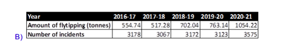
B) The total net disposal costs of fly-tipping during this period were around £400k.
These costs do not take into account any costs associated with the collection of flytipping or the management of the waste transfer station that fly-tipping is taken to.
C) Number of fines:
2016 – 1
2017 – 3
2018 – 5
2019 – 2
2020 – 0
Monies received:
2016 – £400
2017 – £800
2018 – £800
2019 – £0
2020 – £0
Question 8:
Please confirm (a) how LBB’s 50% ‘recycling’ rate is calculated – is it an ‘input’ based on collection, or an ‘output’ based on materials truly recycled; and (b) what percentage of the so-called recycling rate is incinerated?
Answer to Question 8:
A. Bromley Council’s annual recycling rate is calculated by the Department of the Environment, Food and Rural Affairs based on the quantity of recyclable materials that are sent to reprocessors. More details of the exact calculation can be found on the Waste Data Flow website.
B. 0% of the 50% recycling rate is sent for energy recovery or incineration. Any materials that are sent for energy recovery following the sorting process at the Material Recycling Facility are recorded as energy recovery and excluded from the final recycling rate. The use of energy recovery has effectively avoided any of Bromley Council’s collection going to landfill.
Question 9:
The DfE’s “Home to school travel and transport guidance” requires local authorities to promote sustainable travel to schools. Specifically it states councils must “publish their Sustainable Modes of Travel Strategy on their website by 31 August each year”. Was this done in 2020, and will it in 2021?
Answer to Question 9:
Bromley publishes a three-year Transport Plan (LIP) and the annual Portfolio Plan, alongside regular updates to this Committee on the targets set in these two documents.
Question 10:
In the Local Improvement Plan, Bromley Council has set the goal for 2% of daily trips originating in the borough to be made by bicycle, could the council please confirm if this target has been met, how it is measured and what changes were implemented to achieve this?
Answer to Question 10:
The data is measured and supplied by TfL. Bromley has yet to receive the data for 2019/20 or 2020/21. When this information is received it will be reported to this committee. The last data we have is for 2018/19 shows that 0.8% of daily trips originating in the borough were made by bicycle. Over recent years the Council has invested significant resources to support cycling, with the installation of new cycle routes, some permanent and some “experimental”, alongside targeted cycle training. Even during the past year, Officers have continued to deliver one-to-one escorted cycle rides to help residents feel safe to cycle to places of work. New cycling infrastructure includes permanent routes in Orpington and Penge, plus other routes such as in Beckenham and Crystal Palace.
Question 11:
Bromley residents actively clean, sort and store their waste for recycling; but there have been worrying news reports of recyclable waste being sent offshore. How can Bromley residents check how Veolia is disposing of their recyclable waste, how it is being processed & where it is going.
Answer to Question 11:
Bromley Council aims to be transparent about recycling and waste management. Information about what happens to the waste and recycling collected from residents and how both Veolia and the Council ensure that your recycling is recycled is available on the Council’s website. You can be confident that the loose plastic material that is seen on media reports of UK material being dumped in countries like Turkey and Malaysia, is not from Bromley. This is not only because of the audit process undertaken but also because at the Material Recycling Facility Bromley plastics are bailed into cubes of a single plastic type. Sadly, there are a small number of unscrupulous or illegal operators exporting mixed plastics that may not have been properly sorted and therefore not all be recyclable. Bromley Council places a high importance on recycling and managing waste sustainably.
Question 12:
Bromley Council’s Local Improvement Plan has set the goal of 30% of daily trips originating in the borough being made by foot: could the Council please confirm whether this target has been met, how it is measured, and what changes were made to implement and enable progress towards it?
Answer to Question 12:
The data is measured and supplied by TfL. Bromley has yet to receive the data for 2019/20 or 2020/21. When this information is received it will be reported to this committee. The last data we have is for 2018/19 which shows that 25.4% of daily trips originating in the borough were made by foot. As many switchable journeys are in respect to the school journey, the Council has invested resources in making sure that this Borough has amongst the highest number of effective, Gold and Silver accredited, school travel plans across London. The Council supports schools to facilitate travel by foot for their pupils who wish to walk. The Council also installs various improvements to the highway infrastructure to support walking, such as five new zebra crossings on high pedestrian routes in 2020.
Question 13:
In October 2020 Bromley exported 60% of waste plastic bottles. 63% PET bottles to the Netherlands, Romania and Spain and 65% PP bottles to the Netherlands. Could you please explain how they are recycled in those countries, which percentage are ever incinerated, put into landfill or moved to other countries?
Answer to Question 13:
Absolutely no recyclable plastic bottles that have been collected from residents for recycling are disposed of either by energy from waste or landfill. Plastic bottles collected from residents are sorted according to polymer type and bailed before being transferred to a reprocessing facility in the UK or overseas. At the reprocessing facility whether that is in the UK, the Netherlands, Romania or Spain, the following steps are undertaken to recycle the plastics: 1. Washing – to remove any labels, adhesives, food and dirt 2. Shredding – into smaller pieces 3. Extruding and compounding – melted and crushed together to form pellets, the pellets are valuable feedstock that is used to make new plastic products. Bromley’s plastic bottles are made into a range of new products included new plastic bottles, fibres for clothing and sleeping bags.
Question 14:
A new housing/care home development is opening off South Eden Park Road adding 280 new homes and 100 units for elderly which will dramatically increase traffic. The council has approved this development. When will the Council install a pedestrian crossing on this road?
Answer to Question 14:
Each location on our streets is investigated to see if any infrastructure changes are needed, such as pedestrian crossings. With resources being finite, they must be prioritised where they are most needed. Volumes of pedestrians crossing at a particular point is a key consideration as we want crossings to be well used. South Eden Park Road already has a number of crossing points comprising central reservations and associated visible signage, principally on school routes. Reducing the number of casualties on Bromley’s streets has long been a priority for this Council, with resources being targeted at vulnerable road users and at locations where data tells us that there is a greatest risk of road casualties. Once we have successfully tackled the locations where, unfortunately, serious incidents are currently occurring, other high risk locations can be addressed. Data would not at present suggest that additional or improved crossings are required on South Eden Park Road.
However, pedestrian movements will be monitored over the coming years and, as I say, resources will be prioritised accordingly.
Question 15:
In the Local Improvement Plan, Bromley Council has set the goal of 30% of daily trips originating in the borough made by foot, could the council please confirm if this target has been met, how it is measured and what changes were implemented to achieve this?
Answer to Question 15:
The data is measured and supplied by TfL. Bromley has yet to receive the data for 2019/20 or 2020/21. When this information is received it will be reported to this committee. The last data we have is for 2018/19 which shows that 25.4% of daily trips originating in the borough were made by foot. As many switchable journeys are in respect to the school journey, the Council has invested resources in making sure that this Borough has amongst the highest number of effective, Gold and Silver accredited, school travel plans across London. The Council supports schools to facilitate travel by foot for their pupils who wish to walk. The Council also installs various improvements to the highway infrastructure to support walking, such as five new zebra crossings on high pedestrian routes in 2020.
Question 16:
In the Local Improvement Plan, Bromley Council has set the goal of reducing all collisions by 10%, could the council please confirm if this target has been met, how it is measured and what changes were implemented to achieve this?
Answer to Question 16:
The Council is aiming to achieve at least a 10% reduction in all road casualties by 2022 from the 2015-2019 baseline. Although data for 2020 is still provisional, it would seem that we have achieved much more than a 10% reduction last year. However, for much of that time the country was in lockdown, which is bound to have played its part, so there will be absolutely no complacency. The primary focus will continue to be on reducing the number of road user casualties killed or seriously injured (often life changing injuries). Experience has shown that individual years can represent ‘blips’ in the data and it is the trend that is important. Bromley’s LIP details the range of interventions and road safety education approaches which form the basis of our actions to tackle road safety issues.
Question 17:
The recycling rate has now dropped to 47% for the year 2020-21. When was the last time the annual recycling rate was lower than 47% and what are the main issues that caused this drop in the recycling rate?
Answer to Question 17:
Recycling performance is complex, 47% under the context of a global pandemic is a good achievement. The main reason for lower recycling rates in 2020/21 is the increase in non-recyclable refuse. This increase is likely to be associated with more people being at home and working from home; home and business premise clearances and a return to single use items, particularly Covid related PPE. Many local authorities are experiencing these changes to their waste tonnages. The suspension of some of our recycling services in 2020 and some of our wet paper and card being sent to energy recovery instead of recycling has also had an impact on Bromley’s recycling rate. The last time our official and audited recycling rate was 47% was in 2016/17. It is worth noting that the recycling rate reporting in the Environment Portfolio Plan is the Council’s real time unaudited recycling rate. Central government review and finalise Bromley’s waste and recycling data to generate Bromley’s official recycling rate. The trend from past years is that following the review process, Bromley official recycling rate is a couple of percentages higher than the unaudited recycling rate published in the Environment Portfolio Plan.
Question 18:
How much was the drop in the recycling rate attributed to wet paper and card having to be incinerated? What percentage of paper and card recycling could not be recycled in Jan, Feb and Mar 2021 when the rate dropped to 34%, 34% and 50% respectively?
Answer to Question 18:
January and February 2021 had particularly high numbers of days with precipitation, and as a result a higher proportion of paper and card collected for recycling had a higher moisture content than is acceptable for recycling at the paper sorting facility. The table below shows the proportion of paper and card recycling that was sent to create energy rather than being recycled:
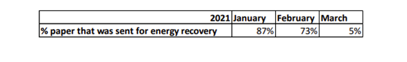
This had an impact of 6% on the household recycling rate during the period January to March 2021. Across 2020/21, the household recycling rate was 2% lower than it would have been had 100% of paper and card collected been recycled.
Question 19:
It’s great that the Portfolio Holder has shared an overview and update document for agenda item 6, but it’s a huge table and very difficult to navigate as a PDF. In future, please could this document (and others like it) be shared as a spreadsheet (e.g. Microsoft Excel) so that it is easier for residents to read it?
Answer to Question 19:
Our performance management framework is detailed and complex and this naturally means that the update document is also detailed, which can make navigation through the document challenging at points, be this with a paper version or the pdf version on the website. Excel spreadsheets may be preferred by some but they will not be accessible for everybody either. We will carefully consider how to better display this information to allow interested readers to navigate through the information.
Question 20:
Given that we are in a climate emergency, please can the Portfolio Holder explain how Bromley Council decided that the 2021/22 target for children travelling to school by foot, cycle or scooting should be 50%?
Answer to Question 20:
The Council has worked closely with schools for many years to support them such that those pupils who can and who wish to travel to school by active means can do so. Targets are set to be realistic and to provide a measure against which to monitor progress.
Question 21:
The recycling rate has now dropped to 47% for the year 2020-21. When was the last time the annual recycling rate was lower than 47% and what are the main issues that caused this drop in the recycling rate?
Answer to Question 21:
Recycling performance is complex, 47% under the context of a global pandemic is a good achievement. The main reason for lower recycling rates in 2020/21 is the increase in non-recyclable refuse. This increase is likely to be associated with more people being at home, home and business premise clearances and a return to single use items. Many local authorities are experiencing these changes to their waste tonnages.
The suspension of some of our recycling services in 2020 and some of our wet paper and card being sent to energy recovery instead of recycling has also had an impact on Bromley’s recycling rate. The last time our official and audited recycling rate was 47% was in 2016/17. It is worth noting that the recycling rate reporting in the Environment Portfolio Plan is the Council’s real time unaudited recycling rate. Raw unaudited waste and recycling data provided to central government, reviewed and finalised to produce Bromley’s official recycling rate. The trend from past years is that the audited recycling rate is a couple of percentages higher than the unaudited recycling rate.
Question 22:
How much was the drop in the recycling rate attributed to wet paper and card having to be incinerated? What percentage of paper and card recycling could not be recycled in Jan, Feb, and Mar 2021 when the rate dropped to 34%, 34% and 50% respectively?
Answer to Question 22:
January and February 2021 had particularly high numbers of days with precipitation, and as a result a higher proportion of paper and card collected for recycling had a higher moisture content than is acceptable for recycling at the paper sorting facility. The table below shows the proportion of paper and card recycling that was sent to create energy rather than being recycled:

This had an impact of 6% on the household recycling rate during the period January to March 2021. Across 2020/21, the household recycling rate was 2% lower than it would have been had 100% of paper and card collected been recycled.
Question 23:
Over 4,500 pupils travel to and from the schools along South Eden Park Road every day and traffic alternates between dangerously congested and dangerously fast. Crossing points around the schools (and pavements around Langley/Unicorn) are woefully inadequate for this many children. What can be done to improve safety for pedestrians?
Answer to Question 23:
Reducing the number of casualties on Bromley’s streets has long been a priority for this Council, with resources being targeted at vulnerable road users and at locations where data tells us that there is a greatest risk of road casualties. Once we have successfully tackled the locations where, unfortunately, serious incidents are currently occurring, other high risk locations can be addressed. Data would not at present suggest that additional or improved crossings are required on South Eden Park Road. Central reservations and associated highly visible road infrastructure, which also act as traffic calming, currently provide suitable crossing locations on South Eden Park Road. The Council’s School Travel Planners will continue to engage with the schools adjacent to South Eden Park Road to ensure that safe travel to school is supported. This may include discussions about safe crossing places for pupils. However, pedestrian movements will be monitored over the coming years and, as I say, resources will be prioritised accordingly.
Question 24:
The Council mightn’t enforce speeding, but they are responsible for safety. There are 6 schools and a pre-school (c4,600 pupils) in 1.5miles between the Chinese roundabout and West Wickham station. Please explain why this area (where speeding is a problem) doesn’t qualify for 20 mph zone or permanent signage. The speed of cars on Beckenham road BR4 is also of concern.
Answer to Question 24:
The experience the Council has from the various parts of the Borough where area-wide 20mph limits have been installed in the past is that we receive very many complaints about speeding, despite the lower limit. Research commissioned by the DfT showed that following the introduction of signed-only 20mph limits the median speed fell by just under 1mph and found no significant change in collisions and casualties. In light of the lack of evidence that introducing widespread 20mph limits is the most effective approach, Bromley has no plans to introduce such area-wide 20mph zones. However, in light of evidence that drivers respond better to warnings or regulations where they can see the reason for them, part time advisory 20 limits are being introduced around schools in the Borough, on a case by case basis.
Question 25:
Agenda item 6 includes a document which shows the Council wants to increase the proportion of children travelling to school on foot, bicycle or scooter. My understanding is that Bromley Council secured funding for 17 School Streets but has only created six. Can the portfolio holder explain this?
Answer to Question 25:
The Council has worked closely with schools for many years to support them such that those pupils who can and who wish to travel to school by active means can do so. As many switchable journeys are in respect to the school journey, the Council has invested resources in making sure that this Borough has amongst the highest number of effective, Gold and Silver accredited school travel plans across London. The Council supports schools to facilitate travel by active means for their pupils. The Council also installs various improvements to the highway infrastructure to support active travel, such as five new zebra crossings on high pedestrian routes in 2020. One measure considered last year as an emergency response to the Covid pandemic was the use of temporary School Streets. These temporary School Streets were widely offered to schools, but after due consideration only six schools in the borough chose to take on this approach to managing traffic around their premises. Some schools preferred to have social distancing measures installed, such as widened footways.
Question 26:
The report in Portfolio Holder Update and ECS Performance Review states that no data is available for the percentage of children travelling to school by foot, cycle or scooting for 2020-2021. When will this be available, and what is the council’s target for 2021-2022 , 2022-23 and 2023-24. What steps have been put in place to achieve these targets?
Answer to Question 26:
Schools were closed last summer when the data would normally be gathered about percentage of children travelling to school by foot, cycle or scooting. We are hoping to have data for this year’s travel modes in time for the September ECS PDS committee meeting. Targets for future years are yet to be set. As many switchable journeys are in respect to the school journey, the Council has invested resources in making sure that this Borough has amongst the highest number of effective, Gold and Silver accredited school travel plans across London. The Council supports schools to facilitate travel by active means for their pupils. The Council also installs various improvements to the highway infrastructure to support active travel, such as five new zebra crossings on high pedestrian routes in 2020.
Question 27:
The report from the in portfolio holder update states that no data is available for school travel plans for any period since 2014. Why is this, is this a new metric and when can we expect this data?
Answer to Question 27:
This is a new target and data should be available at the next PDS committee meeting in September.
Question 28:
The residents of Palace Estates warmly welcome the Bromley Town Councillors work to set up a speed check on Murray Ave. Can the Portfolio Holder address longer-term solutions to dangerous speeding witnessed throughout the borough, as Councillors themselves have repeatedly proclaimed, drivers in Bromley completely disregard speed limits?
Answer to Question 28:
Bromley Council has and will continue to target finite resources at the locations where data tells us that there is a greatest risk of road casualties. Some drivers will drive at inappropriate speeds whatever measures are taken by the Council. Murray Avenue has had vertical traffic calming measures in place for many years, yet some drivers will still drive at inappropriate speeds here, even when children are on their way to school. Thankfully, there is not a collision issue recorded for Murray Avenue. We have an award winning education programme aimed at new (teenage) drivers to educate them of the dangers of speeding. This has resulted in reduced serious accidents in this age group.
Question 29:
In the LIP3, the council has rightly set objectives to increase active travel, cycling and reduce KSIs; could the council agree that 20mph speed limits on residential roads would help meet these important targets as a sensible person going 20mph will prevent the driver behind from speeding?
Answer to Question 29:
Reducing the number of casualties on Bromley’s streets has long been a priority for this Council, with resources being targeted at vulnerable road users and at locations where data tells us that there is a greatest risk of road casualties. Once we have successfully tackled the locations where, unfortunately, serious incidents are currently occurring, other high risk locations can be addressed. In light of the lack of evidence that introducing widespread 20mph limits is the most effective approach, Bromley has no plans to introduce such area-wide 20mph zones. However, in light of evidence that drivers respond better to warnings or regulations where they can see the reason for them, part time advisory 20 limits are being introduced around schools in the Borough, on a case by case basis. The experience the Council has from the various parts of the Borough where areawide 20mph limits have been installed in the past is that we receive very many complaints about speeding, despite the lower limit. Research commissioned by the DfT showed that following the introduction of signed-only 20mph limits the median speed fell by just under 1mph and found no significant change in collisions and casualties.
Question 30:
Your website lists three types of temporary road closures for which application can be made, along with their fees (£190, £564 and £1,680). Please provide broad categories or examples of the events which would be covered by each type of closure.
Answer to Question 30:
The £190 fee is in fact for parking suspensions rather than a closure of the whole road width, which are sometimes required for events to happen successfully. The £564 fee is for planned road closures to facilitate events such as a street party on the highway where a formal closure will be needed. The £1,680 fee is for closures required to facilitate works on or adjacent to the highway, where such closure will be required for safe operation by, most often, a public utility company. These are the formal costs of a closure, other costs pertaining to the event such as barriers, stewarding etc. are the organisers responsibilities.
Question 31:
In respect of each type of road closure, please provide a breakdown of how the cost is calculated, e.g., advertising, officer time etc.
Answer to Question 31:
I cannot provide a breakdown of costs, but the fees are benchmarked against other local authorities and are competitive in that respect. The fees charged ensure that all Council costs are recovered, which includes staffing, legal, advertising and street notice costs.
Question 32:
There is currently no safe way for children attending the Langley or Unicorn Schools to cross South Eden Park Road and a new petition for a crossing has gathered nearly 500 signatures. What is the Council’s position on installing a crossing on this road?”
Answer to Question 32:
Reducing the number of casualties on Bromley’s streets has long been a priority for this Council, with resources being targeted at vulnerable road users and at locations where data tells us that there is a greatest risk of road casualties. Once we have successfully tackled the locations where, unfortunately, serious incidents are currently occurring, other high risk locations can be addressed. Data would not at present suggest that additional or improved crossings are required on South Eden Park Road. Central reservations and associated highly visible road infrastructure, which also act as traffic calming, currently provide suitable crossing locations on South Eden Park Road The Council’s School Travel Planners will continue to engage with the schools adjacent to South Eden Park Road to ensure that safe travel to school is supported. This may include discussions about safe crossing places for pupils. However, pedestrian movements will be monitored over the coming years and, as I say, resources will be prioritised accordingly.
Question 33:
Mayoral data demonstrates that most pupils at the Langley and Unicorn Schools must cross South Eden Park Road to get to school however no crossing is available beyond the traffic refuges. What is the Council’s position on installing a crossing on this road.
Answer to Question 33:
Same as for question 32.
Question 34:
What are they doing to help encourage safe walking and cycling in Chislehurst – War Memorial junction – being one example which is used daily by parents/young children at St Nicholas CE Primary school and Coopers secondary school but lacking a safe crossing?
Answer to Question 34:
Many switchable journeys are in respect to the school run, therefore the Council has invested resources in making sure that this Borough has amongst the highest number of effective, Gold and Silver accredited, school travel plans across London. The Council supports schools to facilitate travel by foot and by bus for their pupils who wish to travel this way. School travel plans can lead to improvements to the walking infrastructure near to schools, such as the installation of a new zebra crossing in Homesdale Road, or to improvements at bus stops. Road safety education is also key to helping pupils make the choice to walk, cycle or take the bus to school. Across the borough one way we have been successful in encouraging cycling and walking has been to identify and signpost quieter routes for pedestrians and cyclists to use. We therefore will avoid changes that risk diverting traffic from main roads onto quieter roads and might discourage the existing pedestrians and cyclists who are using those roads.
Question 35:
Given the Bromley Biodiversity Plan and Council’s promise (at February CCP) to address the decline of native flora & invertebrates by starting trials of the long discussed biodiversity friendly verges in 2-3 areas of the borough by Autumn 2021, please confirm all investigations & meetings will be concluded this summer to ensure trials begin September 2021?
Answer to Question 35:
It is anticipated that such a trial will commence in autumn 2021 with the launch of information materials, communications and consultations with the cutting regime changing on subsequently selected sites taking place in 2022. In 2021 idverde will continue to deliver their contractual requirements in regard to verge management. The autumn sees cuts to areas of green spaces currently managed for biodiversity, so a start in the spring is appropriate.
Question 36:
While it is important that they are connected to green spaces (e.g. parks, golf courses, greens), given some home owners have paved drives and gardens unsuitable for wildflowers, please confirm that trials of pollinator friendly verges will not rely upon neighbouring gardens changing their planting to complement such verges.
Answer to Question 36:
As you highlight verges in isolation are not sufficient to address biodiversity. The approach to such verges is subject to a number of considerations both bio-diversity and most importantly consultation with local residents. The support and most likely involvement of local residents will be key going forward as will be education. We will have to consider education/explanation without increasing street clutter. At this point we cannot comment on front gardens or whether there may be any correlation between how residents manage their front gardens and their views on pollinator friendly verges.
Question 37:
The Government plans to reduce greenhouse emissions by 78% by 2035 vis-à-vis 1990. This is a very bold target, and Government needs the help of Councils to achieve it. Would you agree that Bromley Council’s strongest lever is its control over transport infrastructure? And shouldn’t Bromley therefore be going out of its way to implement the Government’s ‘Gear Change’ strategy that encourages people to make less use of their motor cars and engage in more active travel?
Answer to Question 37:
Last year the Council installed a number of new zebra crossings and cycle lanes. Bromley will continue to invest in appropriate infrastructure changes to support cycling and walking, to give road users options as to how they travel through the Borough.
Question 38:
Re: problem of speeding on South Eden Park Road. Children from all the Langley Schools (secondary and junior); Unicorn school; St David’s school, and parents and children needing to cross en route to Oak Lodge school all have to cross this very busy road. In addition, many dog walkers cross this road to take their dogs to Blake’s Rec and High Broom woods. There are no traffic calming measures, and no zebra or light-controlled crossing to help them cross safely. What is the council going to do to help children and parents cross this road safely?
Answer to Question 38:
Reducing the number of casualties on Bromley’s streets has long been a priority for this Council, with resources being targeted at vulnerable road users and at locations where data tells us that there is a greatest risk of road casualties. Data would not at present suggest that a crossing is required on South Eden Park Road. The Council’s School Travel Planners will continue to engage with the schools adjacent to South Eden Park Road to ensure that safe travel to school is supported. This may include discussions about safe crossing places for pupils.
Question 39:
Re: problem of speeding on South Eden Park Road. There is a big problem with speeding on this road. There are no traffic calming measures (such as the ones you find in many areas where speeding is a problem where the driver’s speed flashes up with a message to slow down). Will the Council install some traffic calming measures to tackle this problem, and to safeguard the very many children and adults who have to cross this road?
Answer to Question 39:
Through engagement between the Council and the local schools, alongside traffic surveys, the Council will seek to determine whether there are suitable measures that might improve the behaviour of some drivers on this route and therefore improve journeys for pedestrians. Vehicle activated signs will be amongst measured given consideration.